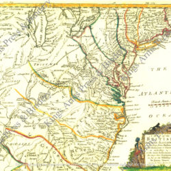
Map of the Western Parts of the Colony of Virginia as Far as the Mississippi
$12.00
A young George Washington kept a journal of his activities during his mission to the Ohio region in 1753. The journal was published in Willamsburg in 1754, and copies were sent to London-based publisher Thomas Jefferys who published the work, along with this map, in 1754. As this map was not included in the original Williamsburg edition, Jefferys may have based his geography on the western portion of Joshua Fry’s and Peter Jefferson’s preliminary work for their landmark map of Virginia.
The London edition of George Washington’s Journal, (also found on this site under Military Narratives) which recorded his 1753 military reconnaissance to Fort Duquesne and the Ohio River Valley, included this map of western Virginia and Pennsylvania. British General Edward Braddock led his unsuccessful 1755 campaign through this area at the beginning of the French and Indian War. The well-trained British troops, which included the young Washington, were soundly defeated by smaller, less-disciplined French and Indian forces at the Battle of the Monongahela. With Braddock and other British officers killed or severely wounded, Washington helped lead the retreat. Battle experience like this helped prepare him for leadership during the Revolutionary War.
Taken from the London edition of Washington’s Journal to the French, this large map (18 x 24), displays French and British forts in the Ohio. Like most maps of the period, the Indian tribes in the region are noted. Very nice and good for French and Indian War use Can be water colored. Watermark does not appear on purchased documents.