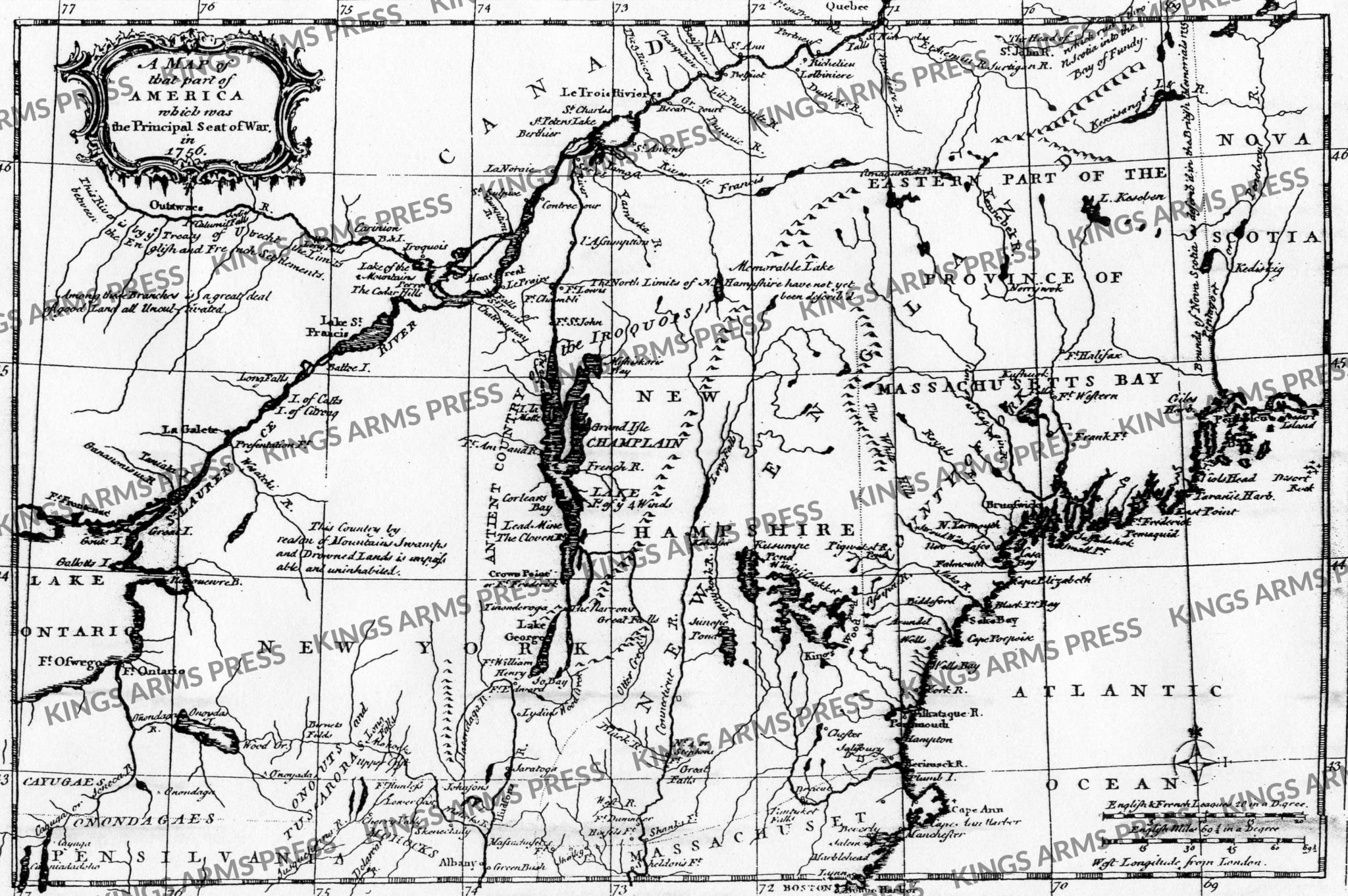
Map of that Part of America Which is the Principal Seat of War in 1756
$12.00
Detailed map of New England and the Northern Colonies, intended to inform the British public of the regions and progress of the battles being fought during the French & Indian War.
At a time when news from the American Colonies traveled slowly, the earliest graphical information available to the British public frequently came from “magazines.” The map extends from Lake Ontario and Fort Ontario to western Nova Scoatia, centered on Lake Champlain and the Iriquois Country.
The map includes notes on the Treaty of Utrecht and other boundaries, along with the various forts southeast of the St. Laurence River, including Presentation Fort, Ft. Oswego, Ft. Ontario, Ft. St. John, Ft. Lewis, Ft. Chambli, Ft. Fredrick at Crown Point, Ft. William Henry, Ft. Hunless, Shirley Ft., Sheldon’s Fort, Shank’s Fort, Ft. Dummer, No. 4 or Stephen’s Fort, Ft. Halifax, Frank Ft., Ft. Western, etc. Boston Harbor is shown. One of the first seat of the war maps to report on the battles in North America.
This interesting map is taken from the Gentleman’s Magazine and is one of the nicest mass produced maps of the period. It contains much detail concerning the Indian lands and the location of forts, etc. Large 18 x 24. Watermark does not appear on purchased documents.
These maps are oversize and are shipped in a mail tube and may require postage over and above your regular order.
![BRITISH RESENTMENT or the FRENCH fairly COOPT at Louisbourg. London: Printed for T. Bowles in St. Pauls Church Yard, & Jno. Bowles & Son, in Cornhil [sic], 25 Septr. 1755](https://kingsarmspress.com/wp-content/uploads/2024/12/british-resentment-or-the-french-fairly-coopt-at-louisbourg-london-printed-for-t-bowles-in-st-pauls-church-yard-jno-bowles-son-in-cornhil-sic-25-septr-1755-250x250.jpg)